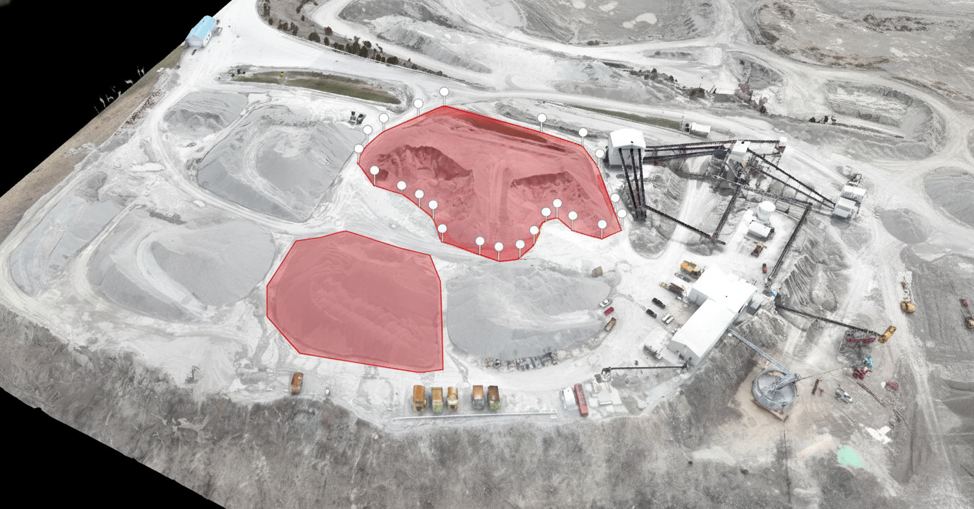
Volumetric Surveys & Stockpile Measurement
Survey-Grade Volumetrics for Earthworks & Inventory
Volumetric surveys & stockpile measurement give you accurate, defensible quantities for every stockpile on site. Using RTK-enabled drone photogrammetry, Nexus Analytics helps contractors, quarries and asset owners across Alberta track materials and earthworks with data that stands up in audits, disputes and boardroom discussions.
For Industries Where Every Cubic Meter Counts
Our volumetric service is engineered for operators who require absolute accuracy for financial reporting, project payments, and operational planning.
For General & Civil Contractors:
- Problem: Disputed quantities and slow traditional surveys delay progress payments and impact project cash flow.
- Outcome: Settle pay applications faster with defensible, third-party data that validates earthwork quantities and resolves disputes before they begin.
For Municipal Public Works & Utilities:
- Problem: Manual tracking of material stockpiles (salt, sand, aggregate) and landfill capacity is time-consuming, unsafe, and imprecise.
- Outcome: Implement a safe, rapid, and repeatable process for monitoring critical inventories and landfill airspace, ensuring regulatory compliance and effective planning.
What's Included in Our Volumetric Survey Service
We provide a complete, end-to-end solution that delivers precise measurements and intuitive reporting.
RTK/PPK-Enabled Aerial Surveys
High-accuracy data capture for survey-grade results.
Dense Point Clouds & 3D Meshes
Creation of detailed, high-fidelity digital terrain models of your site.
Cut/Fill Analysis
Precise calculations comparing design grades to as-built conditions or tracking changes between two dates.
Intelligent Stockpile Delineation
We capture accurate toe-lines and separate complex or touching piles for precise individual measurements.
Per-Pile & Aggregate Reporting
Receive detailed reports for each individual stockpile as well as total site volumes.
Change Detection
Track volume changes over time with timeline-based comparison reports.
How we perform volumetric surveys & stockpile measurement with drones
We start with clear flight planning and compliance with all Transport Canada RPAS regulations. On site, our pilots capture overlapping aerial imagery with RTK positioning for survey-grade accuracy. Back in the office, we process the data with advanced photogrammetry software to generate detailed 3D point clouds and surface models for each stockpile and earthwork area.
Every step of the workflow is documented so that your results are repeatable, auditable and easy to defend in front of owners, regulators or auditors.
Actionable Deliverables for Your Workflow
You receive structured, verifiable data ready for financial reporting and project management systems.
Deliverables:
- Detailed Volume Tables with per-pile and total quantities (CSV/PDF).
- Annotated Orthomosaic Map showing stockpile locations and delineation.
- 3D Models & Point Clouds (LAS, OBJ) for use in your design software.
- Secure link to a hosted cloud viewer for interactive 3D analysis and measurement.
- QA/QC Report detailing methodology, ground control, and accuracy metrics.
Uncompromising Accuracy and Technology
Expected Accuracy
With our RTK/PPK drones and a robust GCP network, we typically achieve absolute accuracies in the range of 2-5 cm, resulting in volume calculations with 1-3% accuracy under typical conditions.
The Role of Ground Control
GCPs are essential for achieving the highest level of accuracy. We use them to lock the 3D model into its precise real-world position, and independent check shots validate the final result.
Mitigating Limitations
We plan flight paths to minimize occlusions (shadowed areas). While dense vegetation can obscure the ground, our methodology is designed to produce the best possible surface model in all conditions. We clearly note any such limitations in our report.
Turnaround Times & Service Level Agreements
We deliver actionable intelligence at the speed your project demands.
- Standard Delivery: Your complete volume report and data package are typically delivered within 48-72 hours of the flight.
- Rush Options: Expedited processing is available for urgent requirements. Please specify during your quote request.
Common Use Cases & Scenarios
Month-End Inventory
Auditable stockpile measurements for financial reporting at quarries and material yards.
Pay-Quantity Validation
Third-party verification of cut/fill quantities for civil earthworks projects.
Borrow Pit & Lagoon Tracking
Monitor material extraction rates and remaining capacity.
Landfill Capacity Management
Regular surveys to track airspace consumption and optimize cell planning.
Post-Storm Siltation Checks
Measure sediment accumulation in retention ponds or channels after a major weather event.
Why volumetric accuracy matters for your operation
Guessing stockpile volumes or relying on infrequent ground surveys leads to cost overruns, inventory write-offs and uncomfortable conversations with clients and suppliers. With high-resolution aerial data you can:
- Validate progress claims and change orders with third-party measurements.
- Compare “as-built” volumes against tender estimates.
- Plan hauling, crushing and blending based on real inventory, not assumptions.
- Improve safety by keeping staff off steep, unstable piles.
Our measurements integrate smoothly with your existing surveying, engineering and accounting workflows, supporting everything from construction progress tracking to long-term asset management.
For building envelope reviews, see our Thermal & Envelope Inspections service.
If you manage construction projects, our Construction Progress Monitoring service delivers clear, time-stamped site updates.
To learn how drone inspections support broader asset management, read our article “Drone Inspections: Revolutionizing Asset Management.”